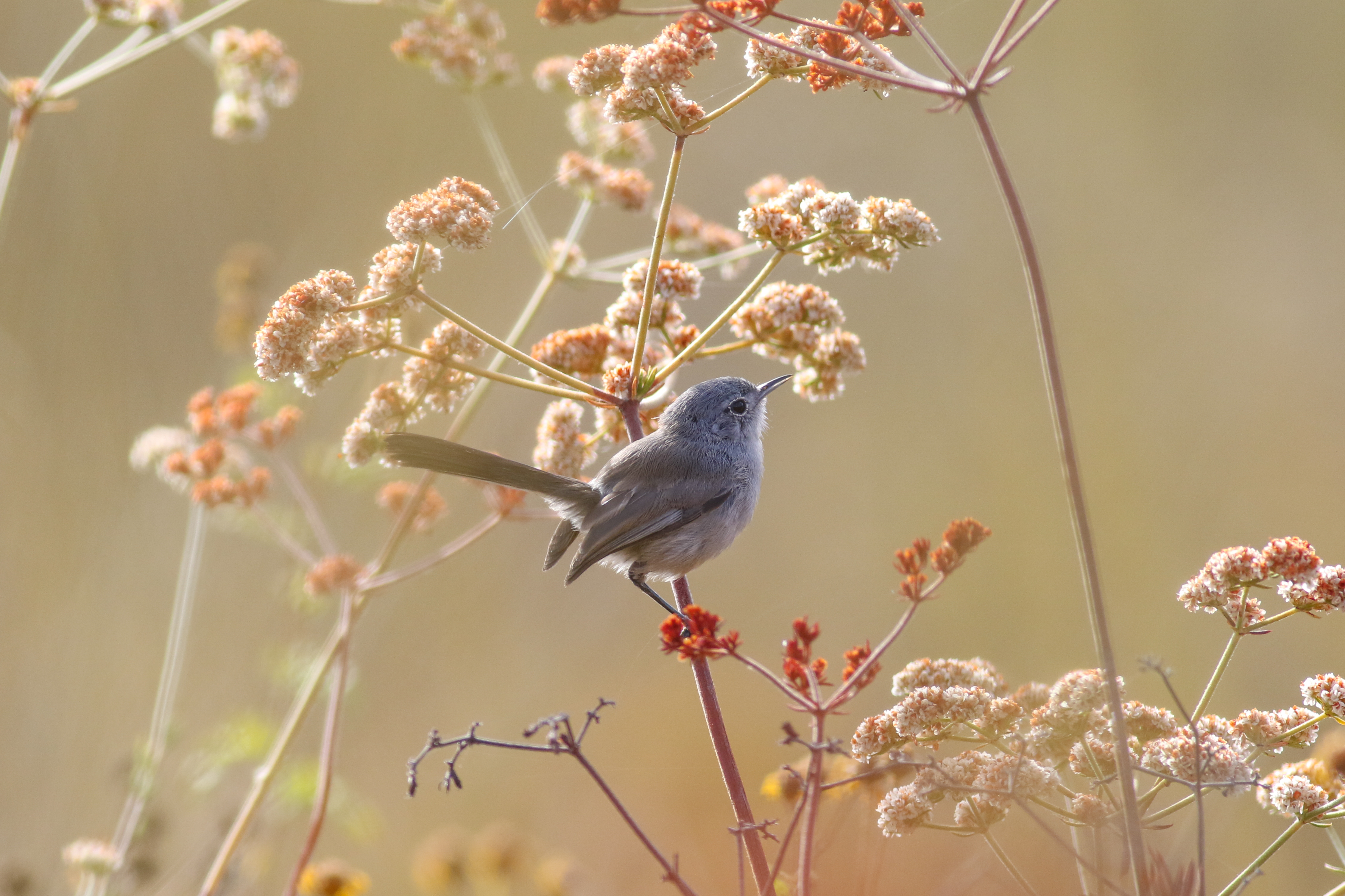
Photo Credit: Alex Houston
Goal: Maintain, enhance and restore coastal sage scrub on Conserved Lands in the MSPA that supports or has the potential to support VF species (i.e., cliff spurge, Palmer's goldenbush, San Diego barrel cactus, snake cholla, Blaineville's horned lizard, California gnatcatcher, San Diego black-tailed jackrabbit) and to incidentally benefit a diverse array of other species (e.g., San Diego thornmint, willowy monardella, Hermes copper, Quino checkerspot, coastal cactus wren) so that the vegetation community has high ecological integrity, and these species are resilient to environmental stochasticity, catastrophic disturbances and threats, such as very large wildfires, invasive plants and prolonged drought, and will be likely to persist over the long term (>100 years).
Management units: 1, 2, 3, 4, 5, 6, 7, 8
In 2020, implement regional and subregional California gnatcatcher monitoring initiated in 2016 to determine the percent area occupied (PAO) by California gnatcatcher in modeled high and very high suitability habitat on Conserved Lands and military lands in the MSPA as part of a larger monitoring program for southern California. Over the next 15 years, determine trends in California gnatcatcher PAO and in their colonization and extinction rates and be able to detect at least 30% change in PAO. Identify associations between habitat and threat correlates with gnatcatcher PAO and with extinction and colonization rates and develop biologically meaningful thresholds for management and to specify management criteria and recommendations.
| Action | Statement | Action status | Projects |
|---|---|---|---|
| IMP-1 | When the results of the 2016 California gnatcatcher surveys become available, coordinate with the regional California gnatcatcher survey group made up of wildlife agencies, land managers and scientists, to determine when the next round of regional surveys should be implemented. It is anticipated that the surveys are likely to be held in 2020. Based on the monitoring results and group recommendations, adjust the habitat model and sampling frame as necessary to better predict suitable habitat in the northern extent of the range. | on hold | |
| IMP-2 | Submit project metadata, monitoring datasets, analyses and reports to the MSP Web Portal. | on hold |
| Criteria | Deadline year |
|---|---|
| Regional and Subregional California Gnatcatcher Surveys completed and report submitted by 2021 | 2021 |
| Threat Name | Threat Code |
|---|---|
| Altered fire regime | ALTFIR |
| Climate change | CLICHN |
| Human uses of the Preserves | HUMUSE |
| Invasive plants | INVPLA |
| Urban development | URBDEV |
Management units: 1, 2, 3, 4, 5, 6, 7, 8
In 2020, implement California gnatcatcher postfire monitoring conducted in 2015 and 2015 to: determine whether there has been further recovery of California gnatcatchers in areas burned in 2003, 2007 and 2014 (i.e., PAO>10%); evaluate if there is a difference in PAO between areas burned in 2003, 2007 and 2014; investigate the relationship between gnatcatcher PAO and vegetation composition, cover and structure; and evaluate the composition, cover and structure of coastal sage scrub in areas with different fire frequencies and patterns of vegetation recovery based upon time since fire, spatial distribution, previous land use, and environmental conditions. Use the regional gnatcatcher and vegetation monitoring protocols to monitor postfire recovery of gnatcatchers and vegetation at sampling points surveyed in 2016. Analyze gnatcatcher and vegetation data to develop overall and site specific vegetation management recommendations for postfire recovery of coastal sage scrub vegetation to support California gnatcatchers.
| Action | Statement | Action status | Projects |
|---|---|---|---|
| RES-1 | Submit project metadata, monitoring datasets, analyses and reports to the MSP Web Portal. | On hold |
| Criteria | Deadline year |
|---|---|
| Postfire California Gnatcatcher Surveys completed and report submitted by 2021 | 2021 |
| Threat Name | Threat Code |
|---|---|
| Altered fire regime | ALTFIR |
| Climate change | CLICHN |
| Human uses of the Preserves | HUMUSE |
| Invasive plants | INVPLA |
| Urban development | URBDEV |
| Metric | Condition | Trend | Confidence |
|---|---|---|---|
1. Proportion Area OccupiedProportion Area Occupied (PAO) of conserved lands in San Diego County |
Concern |
Unknown |
High |
2. Recovery from FireIncrease in Proportion Area Occupied (PAO) of burned habitat |
Concern |
Improving |
High |
|
Artesian Creek Restoration
Approximately 300 acres along Artesian Creek, a tributary of the San Dieguito River, was restored to coastal sage or native riparian. The majority of restored land was previously used for grazing, with an additional two miles of riparian habitat. The project is located between Camino Del Sur and Del Dios Highway, just south and southwest of Lake Hodges. The restoration has been completed, but annual treatment of invasive species remains including ongoing treatment of eucalyptus, tamarix and palms. The focal invasive species included: mustard, French broom, Scotch broom, Spanish Fleabane, arundo, Austrailian salt bush, Brazilian Pepper, caster bean, lapidium latifolia, garland chrysanthemum, bridal creeper, Italian thistle, fountain grass, dittrichia graveolens, artichoke, eucalyptus, tree tobacco, acacia, palms, pampas grass, pride of Maderia, tamarix, and fennel.
|
|
Bernardo Mountain Post-Fire Habitat Recovery Project
Bernardo Mountain is located north of Lake Hodges, west of I-15. The primary goal of this habitat conservation project is to protect the habitat of the federally listed coastal California gnatcatcher, as well as other listed and sensitive animal species such as coastal cactus wren and sensitive plant and wildlife species that are covered under the Multiple Habitat Conservation Plan ("MHCP").
|
|
Calavera Preserve Planning Area Access Control and Habitat Restoration Project
The Restoration Project was implemented in accordance with the Diegan Coastal Sage Scrub Restoration Plan, TransNet EMP Grant Project: Calavera Preserve Planning Area (Restoration Plan), which was prepared by Technology Associates, Inc. (TAIC) (Aug. 24, 2009). The goal of the project was to restore 5 acres of non-native grassland habitat to Diegan coastal sage scrub that is (a) self-sustaining, (b) suitable habitat for the California gnatcatcher, and (3) free of non-native invasive species that could invade adjacent native habitat. In addition to habitat restoration, the City of Carlsbad had an active public outreach program highlighting the benefits of natural open spaces throughout the city.
|
|
California Gnatcatcher Genetic Study - FundSource 1 and 2
We examined individual relatedness patterns and population genetic structure among gnatcatcher aggregations throughout coastal southern California from Ventura to San Diego Counties. To accomplish this goal, we developed a set of highly polymorphic microsatellite loci and sampled 268 individuals throughout the range. With genetic analyses we addressed the following questions:1) How many genetically distinguishable populations exist across the U.S. species range?2) Is genetic relatedness among individuals explained by the amount and distribution of suitable habitat?3) What is the range of dispersal distances between presumptive siblings and parents/offspring?4) What are the patterns of genetic diversity within aggregations across the U.S. range and what is the effective population size?5) How do these results impact future management and monitoring efforts aimed at species recovery?
|
|
California Gnatcatcher Post-Fire Study
This is a planned 5-year study. The purpose of this study is to: 1) Determine whether there has been further recovery of CAGN in areas burned in 2003 (i.e., occupancy greater than 10%). 2) Determine if there is a difference in CAGN occupancy between areas burned in 2003, 2007, and 2014. 3) Determine the relationship between CAGN occupancy and vegetation composition, cover and structure. 4) Determine the composition, cover, and structure of CSS vegetation in areas with different fire histories and evaluate patterns of vegetation recovery based upon lime since fire, spatial distribution, previous land use, and environmental conditions.
|
|
California Gnatcatcher South Coast Regional Monitoring Program
The USGS, USFWS, SDMMP, and the Nature Reserve of Orange County have joined together to develop a long-term coordinated regional monitoring program for the federally-threatened Coastal California Gnatcatcher (Polioptila californica californica) in the United States portion of the species range. Other participants include CDFW, The Nature Conservancy, Western Riverside RCA, Rancho Mission Viejo Conservancy, Naval Weapons Station Fallbrook, Marine Corp Base Camp Pendleton, Marine Corp Air Station Miramar. The goals of this program are to: 1) determine the population status of California Gnatcatchers in southern California on conserved and military lands; 2) track trends in California Gnatcatcher habitat occupancy over time in southern California to identify when thresholds have been met that trigger management actions; and 3) identify habitat attributes and threats associated with gnatcatcher occupancy in order to develop specific habitat-based management criteria and recommendations. To date, there have been no systematic surveys for this species across southern California. Surveys have been conducted periodically in portions of the gnatcatcher's range, particularly on conserved and military lands. However, these surveys have been conducted in different years and with a variety of methods providing different population metrics and as a result do not provide a region-wide estimate. In addition, during the last 15 years, there have been extremely large wildfires in southern California across a substantial portion of suitable habitat for gnatcatchers and there is little information on their status in these burned areas.
The first regional Coastal California Gnatcatcher survey is scheduled for 2016. This survey is planned for conserved lands and those military lands in southern California that choose to participate. The objectives of the regional monitoring program are:
1. In 2016, determine the percent area occupied (PAO) by California Gnatcatchers in modeled high and very high suitability habitat on conserved lands and on participating military lands in southern California.
2. Over the next 15 years, determine long-term trends in California Gnatcatcher PAO and in their colonization and extinction rates in modeled high and very high suitability habitat on conserved lands and participating military lands in southern California and be able to detect at least 30% change in California Gnatcatcher PAO.
3. Beginning in 2016, identify associations between habitat and threat correlates with California Gnatcatcher PAO and with colonization and extinction rates in order to develop biologically meaningful thresholds for management and to specify management criteria and recommendations.
|
|
Coastal California Gnatcatcher Habitat Suitability Model for Southern California
This habitat model was developed to delineate a sampling frame for regional monitoring of coastal California gnatcatchers (Polioptila californica californica) to determine: 1) percent area occupied (PAO) in high and very high suitability habitat across conserved lands and participating military lands in the U.S. range in southern California; 2) changes in PAO over time; and 3) extinction and colonization rates. One purpose of the model is to identify areas recovering from disturbance, such as wildfire, that may not currently support coastal sage scrub vegetation used by coastal California gnatcatchers, but are otherwise highly suitable. In this way, we can monitor gnatcatcher occupancy associated with habitat changes over time.
We used the Partitioned Mahalanobis D2 modeling technique to construct alternative models with different combinations of environmental variables. Variables were calculated at each point in the center of a 150 m x 150 m cell in a grid of points across the southern California landscape. Variables reflect various aspects of topography, climate, land use (percent vegetation and urbanization at 150 m and 1 km scales), Normalized Difference Vegetation Index, and modeled California sagebrush (Artemisia californica) habitat suitability. Due to spatial unevenness in gnatcatcher location data, we divided southern California into five sampling regions and randomly subsampled 50 locations from each region. We repeated this process 1,000 times using a total of 1,063 spatially precise and non-redundant gnatcatcher locations as a calibration dataset. We model-averaged the results from sampling iterations to create a calibration model and partitions for each set of variables. We compared among calibration model-partitions using a validation dataset of 3,205 presence records independently collected from the calibration dataset and an equivalent number of pseudo-absence points randomly selected from the study area grid. For every model-partition, we calculated Habitat Similarity Index (HSI) predictions for presence and pseudo absence points ranging from Very High (0.75 - 1.00); High (0.50 - 0.74); Low (0.25 - 0.49); and Very Low (0 - 0.24). Suitable habitat is identified as grid cells with HSI greater than or equal to 0.5. We calculated Area Under the Curve (AUC) values from a Receiver Operating Curve (ROC) to determine how well models distinguish between presence and pseudo-absence points. We selected a best performing calibration model and partition based upon median HSI calibration and validation values and AUC results.
The top performing model-partition Run 18 Partition 1 of 19 alternative models has an AUC of 0.96 and a median calibration and validation HSI of 0.73 and 0.69, respec
|
|
Fairbanks Ranch/Rancho Santa Fe Invasive Removal and Stream Enhancement
The long-term goal of this project is to restore and enhance wetland/riparian habitat along 3 miles, 200 acres, of the San Dieguito River and reduce fire risk to the surrounding community. Key actions include non-native, invasive plant removal, revegetation with native species, volunteer training, community workshops and education of local residents on how to improve habitat and create Fire-Safe landscapes around their homes. A secondary goal of this project is to highlight the importance of diverse partnerships in conserving habitat along the San Dieguito River. For more information, go to: http://www.ranchosantafereview.com/news/local-news/sd-cm-rsf-restorationproject-20171101-story.html.
|
|
Lusardi Creek Restoration and Invasive Plant Removal
This project is working to eradicate invasive species and support native plants along Lusardi Creek. Many areas have already been treated and are recruiting natives naturally. Other areas are being planted with natives after invasive plant removal. The current goals include: 1) treat artichoke in several upland areas, 2) continue removing tamarix in the creek, 3) treat any regrowing Peruvian pepper, 4) treat any remaining pampas grass or tree tobacco, 5) work on an overall restoration plan. See the map link below for detailed treatment information.
|
|
Otay Water District San Miguel Habitat Management Area Perimeter Fencing Restoration and Threat Reduction Project
The San Miguel Habitat Management Area (HMA) is an approximate 240-acre biological preserve and mitigation bank that was created by the Otay Water District in 1994. The HMA has recently experienced increased illegal entrance and creation of trails throughout the area. The uptick began during the pandemic when people were in search of more outdoor recreation opportunities. Mountain bikers and hikers are drawn to the surrounding USFWS refuge trail system that is open to the public. The HMA's perimeter fencing and gate locks are frequently cut by trail users illegally passing through the HMA to access between the USFWS refuge trail system and the local residential community, causing significant damage and threatening the viability of species and their habitats on the HMA including the coastal California gnatcatcher and burrowing owl. The Project will implement a variety of education-orientated and land management deterrent strategies to reduce these threats. This includes a public outreach and education campaign consisting of coordination with USFWS and SDGE; participation in local community meetings; and removal of HMA trails from apps. Deterrent efforts include installation of new gates, installation of vegetation to close off trails, installation of camera stations, and coordination with local law enforcement to implement enforcement actions.
|
|
USFWS California Gnatcatcher Monitoring 2004-2009
California gnatcatcher occupancy study across San Diego County.
|
|
West Bernardo Mountain HMA Enhancement & Restoration
Project goals are to enhance and restore coastal sage scrub and cactus scrub habitat on the southwest slope of Bernardo Mountain near Lake Hodges. Partially funded by the SANDAG TransNet Environmental Mitigation Program. Contract Number: S1125509
|
Occurs on coastal slopes of S. Calif., ranging from S. Ventura southward through Palos Verdes Peninsula in Los Angeles Co. through Orange, Riverside, San Bernardino and San Diego Cos. into Baja Calif. to El Rosario, Mexico [1].
FT/ CSC
Typically occurs in or near coastal sage scrub habitat; plants of this community include California sagebrush (Artemisia californica), various species of sage (Salvia sp.), California buckwheat (Eriogonum fasciculatum), lemonadeberry (Rhus integrifolia), California encelia (Encelia californica), and Opuntia spp. Ninety-nine percent of all gnatcatcher locality records occur at or below an elevation of 984 feet [1].
Mitochondrial DNA sequencing confirmed the species-level recognition of the Coastal Calif. gnatcatcher, which was calculated to differ from the black-tailed gnatcatcher (P. melanura) by 4.0 percent, similar to differences calculated in the black-capped gnatcatcher (P. nigriceps) and white-lored gnatcatcher (P. albiloris) [10]. A recent genetic study casts doubt on the subspecies status for the northern coastal population that occurs in CSS [11].
Most active and vocal during the morning; a lull in activity usually occurs during mid-day and activity increases again late in the day [2].
Breeding season extends from mid February through mid-August, with the peak of nesting activity occurring from mid-March through mid-May; nest is a small, cup-shaped basket usually found one to three feet above the ground in a small shrub or cactus; clutch sizes range between 3 and 5 eggs, with the average being 4; Juvenile birds associate with their parents for several weeks (sometimes months) after fledging.1 Gnatcatchers typically live for two to three years, although ages of up to five years have been recorded for some banded birds [3].
Diet is primarily leaf- and plant hoppers and spiders; also included in smaller amounts are true bugs, wasps, bees, and ants [4].
Year-round resident [2]. The home range size of the gnatcatcher varies seasonally and geographically, with winter season home ranges being larger than breeding season ranges[7] and inland populations having larger home ranges than coastal [8]. The mean dispersal distance of gnatcatchers banded as nestlings for males was 2.85 km and for females was 3.33 km [9].
Habitat destruction, fragmentation, adverse modification, nest parasitism, agricultural use, such as grazing and field crops, urbanization, air pollution, increases in fire frequency and the introduction of exotics; high fire frequencies and the lag period associated with recovery of the vegetation may significantly reduce the viability of affected subpopulations of the gnatcatcher [5,6].
[1] Subspecies limits and geographic patterns of morphological variation in California gnatcatchers (Polioptila californica). Bulletin Southern California Academy of Sciences 90 (3):118-133.
[2] Mock, P.J., B. L. Jones, and J. Konecny. 1990. California Gnatcatcher Survey Guidelines. ERC Environmental and Energy Services Co.
[3] Braden, G.T., McKernan, R.L., Powell, S.M. 1995. Life History of Polioptila californica californica in western Riverside County, CA. Paper delivered at the Symposium on the Biology of the California Gnatcatcher held 15-16 September 1995, University of California, Riverside.
[4] Burger, J. C., M. A. Patten, J. T. Rotenberry, and R. A. Redak. 1999. Foraging ecology of the California gnatcatcher deduced from fecal samples. Oecologia (Berlin) 120: 304-310.
[5] USFWS. 2010. Coastal California gnatcatcher (Polioptila californica californica) 5-year Review: Summary and Evaluation. Carlsbad. September 29.
[6] USFWS 1993. Threatened coastal California gnatcatcher; final rule and proposed special rule. Federal Register 58, number 59.
[7] Bontrager, D.R. 1991. Habitat requirements, home range and breeding biology of the California gnatcatcher (Polioptila californica) in south Orange County, California. Unpublished technical report prepared for the Santa Margarita Company, Rancho Santa Margarita, CA. 19 pp.
[8] Atwood, J.L., and D.R. Bontrager. 2001. California gnatcatcher (Polioptila californica). In Poole, A., and F. Gill (eds.). The birds of North America, No. 574. 32 pp.
[9] Atwood, J. L., S. H. Tsai, and A. M. L. Miller. 1996. California gnatcatchers, cactus wrens, and conservation of coastal sage scrub on the Palos Verdes Peninsula. Progress Report No. 4. Unpublished technical report, Manomet Observatory for Conservation Sciences, Manomet, Massachusetts. 15 pp. + appendices.
[10] Zink, R. M., and R. C. Blackwell. 1998. Molecular systematics and biogeography of arid land gnatcatchers (Genus Polioptila) and evidence supporting species status of the California gnatcatcher (Polioptila californica). Molecular Phylogenetics and Evolution 9: 26-32.
[11] Zink, R.M., J.G. Groth, H. Vazquez-Miranda, and G.F. Barrowclough. 2013. Phylogeography of the California gnatcatcher (Polioptila californica) using multilocus DNA sequences and ecological niche modeling: implications for conservation. The Auk, Vol. 130, No. 3, pp. 449-458.