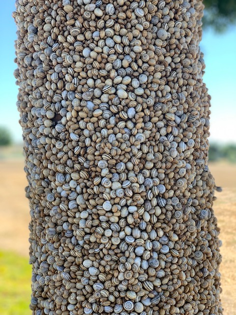
Invasive snail
Photo Credit: Chi Tran, concerned citizen
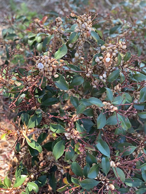
Invasive snail
Photo Credit: Chi Tran, concerned citizen
Goal: The overarching goals for addressing invasive animal species in the MSPA are: (1) Protect intact, unspoiled habitat from new or expanding invasive animal species; (2) Detect new invasive species and new invasions early on and control them before they have a chance to establish; (3) Address invasive species using the response appropriate for the level of invasiveness ensuring higher priority invasive animal species are addressed first
Management units: 1, 2, 3, 4, 5, 6, 7, 8, 9, 10, 11
Starting in 2017, prepare an invasive animal management plan for all invasive animals potentially in the MSPA (including but not limited to Argentine ants, GSOB, SHB, invasive aquatic animals, brown-headed cowbirds, and feral cats) with a categorization of threat level and impact to MSP species and prioritization of management actions.
| Action | Statement | Action status | Projects |
|---|---|---|---|
| PRP-1 | Coordinate with land managers and other invasive animal agencies to identify existing and potential invasive animals in the MSPA and surrounding regions and categorize their threat and impact to MSP species and habitats. | In progress | |
| PRP-2 | The invasive animal management strategy should prioritize management actions for the next five years and detail tasks, lead entities, responsibilities, timelines, and budgets | In progress | |
| PRP-3 | Submit invasive animal management plan to MSP web portal | waiting for precedent action |
| Criteria | Deadline year |
|---|---|
| Invasive Animal Plan for the MSPA completed by end 2018. | 2021 |
| Threat Name | Threat Code |
|---|---|
| Invasive animals | INVANI |
Management units: 1, 2, 3, 4, 5, 6, 7, 8, 9, 10, 11
Starting in 2019, implement invasive animal management plan actions.
| Action | Statement | Action status | Projects |
|---|---|---|---|
| IMP-1 | Management actions to be determined by the management plan. | waiting for precedent action | |
| IMP-2 | Submit project meta data and management data to MSP web portal. | unknown |
| Criteria | Deadline year |
|---|---|
| By 2021, =1 High Priority Management Action Implemented from the Invasive Animal Management Plan | 2021 |
| Threat Name | Threat Code |
|---|---|
| Invasive animals | INVANI |
Management units: 1, 2, 3, 4, 5, 6, 7, 8, 9, 10, 11
Starting in 2019, monitor the effectiveness of implementation of invasive animal management plan actions.
| Action | Statement | Action status | Projects |
|---|---|---|---|
| IMP-1 | Submit monitoring data and report to MSP web portal | waiting for precedent action |
| Criteria | Deadline year |
|---|---|
| Effectiveness of High Priority Management Actions Determined | 2021 |
| Threat Name | Threat Code |
|---|---|
| Invasive animals | INVANI |
Management units: 1, 2, 3, 4, 5, 6, 7, 8, 9, 10, 11
From 2017-2021, continue to support the existing feral pig eradication program.
| Action | Statement | Action status | Projects |
|---|---|---|---|
| RSUP-1 | Continue coordinating with the regional entity leading the feral pig eradication program and provide support as needed and appropriate. | In progress |
| Criteria | Deadline year |
|---|---|
| Evidence of Feral Pigs Eradicated from the MSPA by 2021 | 2021 |
| Threat Name | Threat Code |
|---|---|
| Invasive animals | INVANI |
Management units: 1, 2, 3, 4, 5, 6, 7, 8, 9, 10, 11
From 2017-2021, implement the regional SHB management strategy in coordination with federal, state, and local partners.
| Action | Statement | Action status | Projects |
|---|---|---|---|
| IMP-1 | Continue coordinating with the regional entity leading the shot hole borer program, implement the SHB strategy, and provide support as needed and appropriate. | In progress | Shot Hole Borer Surveys and Management Techniques |
| Criteria | Deadline year |
|---|---|
| By 2021, =2 High Priority Management Action Implemented from the SHB Strategy | 2021 |
| Threat Name | Threat Code |
|---|---|
| Invasive animals | INVANI |
Management units: 1, 2, 3, 4, 5, 6, 7, 8, 9, 10, 11
From 2017-2021, monitor the effectiveness of implementation of the SHB management strategy
| Action | Statement | Action status | Projects |
|---|---|---|---|
| IMP-1 | Submit monitoring data and report to MSP web portal | In progress | Shot Hole Borer Surveys and Management Techniques |
| Criteria | Deadline year |
|---|---|
| Effectiveness of High Priority Management Actions Determined | 2021 |
| Threat Name | Threat Code |
|---|---|
| Invasive animals | INVANI |
Management units: 3, 4, 5, 6, 8, 9, 10, 11
Annually inspect known areas occupied by arroyo toad to identify and reduce threats that can be managed at the local scale including road crossings, illegal encroachment, off-road vehicle use, non-native plants, trash dumping, grazing by livestock, and incompatible human recreation. Where possible, restrict access to arroyo toad upland and breeding habitats to help prevent disturbance to all arroyo toad life history stages (eggs, larvae, metamorphs and adults). Activities should be restricted in upland habitat year-round and in breeding habitat during the core of the breeding season (March to July).
| Action | Statement | Action status | Projects |
|---|---|---|---|
| IMP-1 | Using a regional "IMG" monitoring protocol, annually inspect significant Arroyo toad occurrences to assess status and quantify potential threats to determine management needs. AID_20161229_1831_100 | Available for implementation | |
| IMP-2 | Roads should be examined for high risk areas for arroyo toad crossing and use. Only slow moving vehicles (<5mph) with an occupant experienced in arroyo toad identification should be allowed on high risk roads after sunset (Zimmitti and Mahrdt 1999). | Available for implementation | |
| IMP-3 | An education program should be implemented that promotes the value of the arroyo toad and informs the public of restrictions and the importance of not disturbing the wildlife. | Available for implementation | |
| IMP-4 | Based upon occurrence status and threats, determine management needs including whether routine management or more intensive management is warranted. | Available for implementation | |
| IMP-5 | Submit monitoring and management recommendations to the MSP web portal | Available for implementation |
| Criteria | Deadline year |
|---|---|
| Annual IMG monitoring of Arroyo toad completed | 2021 |
| Threat Name | Threat Code |
|---|---|
| Altered fire regime | ALTFIR |
| Altered hydrology | ALTHYD |
| Climate change | CLICHN |
| Herbivory/predation | |
| Human uses of the Preserves | HUMUSE |
| Invasive animals | INVANI |
| Invasive plants | INVPLA |
| Urban development | URBDEV |
Management units: 3, 4, 5, 6, 8, 9, 10, 11
Beginning in 2018, conduct routine management actions for arroyo toad identified through the IMG regional protocol monitoring, including protecting populations from detrimental human use (e.g. ORV, trampling, altered hydrology), removing invasive plants, and removing aquatic predators and exotic species (which compete and/or prey on arroyo toads, primarily young) within the known arroyo toad habitat.
| Action | Statement | Action status | Projects |
|---|---|---|---|
| IMP-1 | Perform routine management activities such as protecting occurrences from human disturbance, controlling invasive plants, and removing invasive aquatic animals. | available for implementation | |
| IMP-2 | Submit project metadata and management data to MSP web portal. | available for implementation |
| Criteria | Deadline year |
|---|---|
| Routine Management Completed as Needed Based Upon Monitoring Recommendations | 2021 |
| Threat Name | Threat Code |
|---|---|
| Altered fire regime | ALTFIR |
| Altered hydrology | ALTHYD |
| Climate change | CLICHN |
| Herbivory/predation | |
| Human uses of the Preserves | HUMUSE |
| Invasive animals | INVANI |
| Invasive plants | INVPLA |
| Urban development | URBDEV |
Management units: 3, 4, 5, 6, 8, 9, 10, 11
In 2020 and 2021 (assuming adequate rainfall levels), conduct comprehensive arroyo toad surveys using USGS survey protocols throughout the MSPA on Conserved Lands in known occupied and potential habitat to determine current distribution and status of arroyo toad, collect data on threats and habitat covariates, and identify management needs.
| Action | Statement | Action status | Projects |
|---|---|---|---|
| SURV-1 | Survey known occupied and potantial habitat on Conserved Lands across the MSPA to determine the distribution and abundance of arroyo toad on Conserved Lands. | Available for implementation | |
| SURV-2 | Collect data on threats and identify management needs to support self-sustaining occurrences. | Available for implementation | |
| SURV-3 | Continue to collect genetic samples from all arroyo toads captured. | Available for implementation | |
| SURV-4 | Submit survey data and management recommendations to MSP web portal | Available for implementation |
| Criteria | Deadline year |
|---|---|
| Comprehensive surveys completed for Arroyo toad by 2021 | 2021 |
| Threat Name | Threat Code |
|---|---|
| Altered fire regime | ALTFIR |
| Altered hydrology | ALTHYD |
| Climate change | CLICHN |
| Herbivory/predation | |
| Human uses of the Preserves | HUMUSE |
| Invasive animals | INVANI |
| Invasive plants | INVPLA |
| Loss of connectivity | LOSCON |
| Urban development | URBDEV |
Management units: 3, 4, 5, 6, 8, 9, 10, 11
In 2017, continue to convene with the working group of land managers, scientists, wildlife agencies, and local biologists knowledgeable in arroyo toad to review existing conditions of known occurrences on Conserved Lands, to prepare a plan for management of arroyo toad which considers each site, and to develop a regional monitoring strategy.
| Action | Statement | Action status | Projects |
|---|---|---|---|
| PRP-1 | Convene working group meetings to review existing conditions of known occurrences. | in progress | |
| PRP-2 | Use habitat models developed by USGS and results from survey and genetic analyses to identify suitable areas for long-term management. | in progress | |
| PRP-3 | Conduct site visits as necessary to identify appropriate management actions. | in progress | |
| PRP-4 | Develop an arroyo toad management plan. The plan should prioritize management actions for the next five years and detail tasks, lead entities, responsibilities, timelines, and budgets. | in progress | |
| PRP-5 | Submit management plan to MSP web portal | in progress |
| Criteria | Deadline year |
|---|---|
| Arroyo toad management plan completed by 2018 | 2021 |
| Threat Name | Threat Code |
|---|---|
| Altered fire regime | ALTFIR |
| Altered hydrology | ALTHYD |
| Climate change | CLICHN |
| Herbivory/predation | |
| Human uses of the Preserves | HUMUSE |
| Invasive animals | INVANI |
| Invasive plants | INVPLA |
| Loss of connectivity | LOSCON |
| Urban development | URBDEV |
Management units: 3, 4, 5, 6, 8, 9, 10, 11
Beginning in 2018, implement high priority actions identified in the Arroyo Toad Management Plan.
| Action | Statement | Action status | Projects |
|---|---|---|---|
| IMP-1 | Submit project metadata, management actions and report to MSP web portal | waiting for precedent action |
| Criteria | Deadline year |
|---|---|
| High priority management actions implemented for Arroyo toad | 2021 |
| Threat Name | Threat Code |
|---|---|
| Altered fire regime | ALTFIR |
| Altered hydrology | ALTHYD |
| Climate change | CLICHN |
| Herbivory/predation | |
| Human uses of the Preserves | HUMUSE |
| Invasive animals | INVANI |
| Invasive plants | INVPLA |
| Loss of connectivity | LOSCON |
| Urban development | URBDEV |
Management units: 3, 4, 5, 6, 8, 9, 10, 11
Beginning in 2018, monitor the effectiveness of management actions implemented for the arroyo toad.
| Action | Statement | Action status | Projects |
|---|---|---|---|
| IMP-1 | Submit project metadata, monitoring data and reports to MSP web portal | waiting for precedent action |
| Criteria | Deadline year |
|---|---|
| Effectiveness of implementing high priority arroyo toad management actions determined | 2021 |
| Threat Name | Threat Code |
|---|---|
| Altered fire regime | ALTFIR |
| Altered hydrology | ALTHYD |
| Climate change | CLICHN |
| Herbivory/predation | |
| Human uses of the Preserves | HUMUSE |
| Invasive animals | INVANI |
| Invasive plants | INVPLA |
| Loss of connectivity | LOSCON |
| Urban development | URBDEV |
Management units: 3, 4, 5, 6, 8, 9, 10, 11
In 2021, use the results and recommendations from the Golden Eagle Nesting, Foraging, and Habitat Use Study and the Golden Eagle Genetics Study to develop a comprehensive Golden Eagle Management Plan for managing golden eagle territories with nesting, roosting, and foraging habitat on Conserved Lands within the MSPA (see occurrence table). The plan should include recommendations for managing important foraging habitat to minimize human disturbance to foraging eagles and to improve habitat quality to enhance prey availability, especially during drought periods. The plan should also include specifications to control human disturbance that could discourage nesting, cause nest abandonment, or adversely affect the survival of nestlings, and for managing unstable nest ledges or tree nest sites that are critical to maintaining a breeding pair in territories with limited nesting sites.
| Action | Statement | Action status | Projects |
|---|---|---|---|
| PRP-1 | Prepare a five year plan for maintaining and enhancing golden eagle foraging habitat in grasslands and suitable areas in open coastal sage scrub and chaparral, and for reducing human impacts to foraging eagles. Use the Golden Eagle Nesting, Foraging, and Habitat Use Study and modeling results to identify important foraging areas for golden eagles on Conserved Lands in the MSPA. Specify management to reduce human disturbance in important foraging habitat and to manage invasive annual grasses to promote abundant prey, such as California ground squirrels and black-tailed jackrabbit. Include a mechanism for updating the management plan with monitoring results and specific management recommendations from the Comprehensive Golden Eagle Monitoring Plan. | waiting for precedent action | |
| PRP-2 | Prioritize for management, those nest ledges and trees that are in territories where alternative nest sites are limited. Prepare a nest restoration plan for each prioritized unstable nest ledge or vulnerable nest tree in consultation with a qualified golden eagle biologist. | waiting for precedent action | |
| PRP-3 | Establish procedures for managing human activities within the nest site protective zone, including rerouting trails, closing trails during the breeding season, educational outreach, and enforcement. | waiting for precedent action | |
| PRP-4 | Submit project metadata and Comprehensive Golden Eagle Management Plan to the MSP Web Portal. | waiting for precedent action |
| Criteria | Deadline year |
|---|---|
| Comprehensive Golden Eagle Management Plan Completed by 2022 | 2021 |
| Threat Name | Threat Code |
|---|---|
| Altered fire regime | ALTFIR |
| Human uses of the Preserves | HUMUSE |
| Invasive animals | INVANI |
| Invasive plants | INVPLA |
| Pesticides | |
| Urban development | URBDEV |
Management units: 3, 4, 5, 6, 8, 9, 10, 11
In 2021, use the results and recommendations from the Golden Eagle Nesting, Foraging, and Habitat Use Study and the Golden Eagle Genetics Study to develop a comprehensive Golden Eagle Monitoring Plan for monitoring golden eagle status and assessing nesting, roosting, and foraging habitat on Conserved Lands within the MSPA (see occurrence table). The plan should include standardized monitoring protocols to track the status of eagles at nesting territories, to monitor use of important foraging areas, and to collect habitat and threats covariate data to inform needed management actions.
| Action | Statement | Action status | Projects |
|---|---|---|---|
| PRP-1 | Complete a plan to monitor the status and habitat use of eagles over the long term within the MSPA that is based upon the occupancy monitoring study in the Golden Eagle Nesting, Foraging and Habitat Use Study. The plan should include detailed monitoring objectives, statistically valid sampling design, sampling locations, monitoring timeline, and standardized monitoring protocols to record eagles and important habitat and threat attributes. | waiting for precedent action | |
| PRP-2 | Develop a plan to rapidly assess the condition of important golden eagle foraging habitat on Conserved Lands across the MSPA using a standardized protocol, statistically valid sampling design, and designated sampling locations. The protocol should describe monitoring methods to collect specific habitat and threat covariates associated with habitat quality, as identified by the Golden Eagle Nesting, Foraging, and Habitat Use Study. The results of this monitoring will be used to periodically prioritize sites and develop specific recommendations for managing foraging habitat to minimize human disturbance and enhance habitat quality to support abundant eagle prey. | waiting for precedent action | |
| PRP-3 | A golden eagle expert should prepare a protocol, standardized data sheets, and provide periodic training to land managers in how to safely conduct annual nest inspections and determine management needs with minimal disturbance to eagles. The protocol should assess nest sites during the non-breeding season to identify nest ledges that are unstable and nest trees that are vulnerable to loss from threats such as wildfire, pests, and fungal pathogens. | waiting for precedent action | |
| PRP-4 | Submit project metadata, sampling design, sampling locations, protocols and Comprehensive Golden Eagle Monitoring Plan to the MSP Web Portal. | waiting for precedent action |
| Criteria | Deadline year |
|---|---|
| Comprehensive Golden Eagle Monitoring Plan Completed by 2022 | 2021 |
| Threat Name | Threat Code |
|---|---|
| Altered fire regime | ALTFIR |
| Human uses of the Preserves | HUMUSE |
| Invasive animals | INVANI |
| Invasive plants | INVPLA |
| Urban development | URBDEV |
Management units: 3, 4, 5, 6, 8
From 2017 to 2021, continue efforts to expand and translocate occurrences of pond turtles to increase to self-sustaining levels in MU3 in the Sweetwater and Otay River Watersheds (at SPER, RJER, and other suitable sites) and identify, expand, and translocate pond turtles in at least 2 other watersheds in the MSPA, including but not limited to the San Diego and San Dieguito Rivers. Translocation efforts may include management of invasive aquatic and plant species, providing access protection, and headstart efforts.
| Action | Statement | Action status | Projects |
|---|---|---|---|
| IMP-1 | Conduct routine management as needed at the Sycuan Peak ER occurrence of southwestern pond turtle. | In progress | |
| IMP-2 | Conduct routine management as needed at the Rancho Jamul ER translocated occurrence of southwestern pond turtle. | In progress | |
| IMP-3 | Continue to identify, begin management of invasive species, and translocate pond turtle to at least 2 suitable locations in the San Dieguito and San Diego River (e.g. El Monte Ponds, Boulder Creek Preserve) watersheds. | In progress | |
| IMP-4 | Submit monitoring and management data to the regional MSP web portal. | In progress |
| Criteria | Deadline year |
|---|---|
| By 2021, 2 new occurrences translocated in the San Diego and San Dieguito River Watersheds; SPER and RJER occurrences increased by 20% through recruitment from 2017 leve | 2021 |
| Threat Name | Threat Code |
|---|---|
| Altered hydrology | ALTHYD |
| Human uses of the Preserves | HUMUSE |
| Invasive animals | INVANI |
| Invasive plants | INVPLA |
| Loss of connectivity | LOSCON |
| Urban development | URBDEV |
Management units: 3, 4, 5, 6, 8
From 2017 to 2021, continue monitoring the effectiveness of southwestern pond turtle translocation experiments at SPER and RJER (see Table of Occurrences) and any additional translocated occurrences.
| Action | Statement | Action status | Projects |
|---|---|---|---|
| IMP-1 | Continue to monitor the expanded and head-started occurrence and/or habitat at SPER and RJER to document success. | In progress | |
| IMP-2 | Monitor other translocated occurrences to document success. | waiting for precedent action |
| Criteria | Deadline year |
|---|---|
| Southwestern Pond Turtle Translocation Monitoring and Reports Completed Annually | 2021 |
| Threat Name | Threat Code |
|---|---|
| Altered hydrology | ALTHYD |
| Human uses of the Preserves | HUMUSE |
| Invasive animals | INVANI |
| Invasive plants | INVPLA |
| Loss of connectivity | LOSCON |
| Urban development | URBDEV |
Management units: 3, 4, 5, 6, 8
From 2017 to 2021, implement invasive aquatic animal and invasive plant control at natural and translocated pond turtle occurrences as needed to increase recruitment and basking habitat.
| Action | Statement | Action status | Projects |
|---|---|---|---|
| IMP-1 | Follow guidelines in the existing Invasive Plant Strategic Plan (CBI et al 2012) and invasive plant and animal sections of the updated MSP. | In progress | |
| IMP-2 | Submit management data to the regional MSP web portal. | In progress | |
| IMP-3 | Unknown |
| Threat Name | Threat Code |
|---|---|
| Invasive animals | INVANI |
| Invasive plants | INVPLA |
Management units: 3, 4, 5, 6, 8
From 2017 to 2021, biennially inspect the existing occurrences of southwestern pond turtle to identify necessary management actions in order to support the expansion of the occurrence to self sustaining levels.
| Action | Statement | Action status | Projects |
|---|---|---|---|
| IMP-1 | Use regional IMG monitoring protocol to assess status, habitat, and quantify potential threats. | Available for implementation | |
| IMP-2 | Based upon occurrence status and threats, determine management needs including whether routine management or more intensive management is warranted. | Available for implementation | |
| IMP-3 | Submit monitoring and management data to the regional MSP web portal. | Available for implementation |
| Criteria | Deadline year |
|---|---|
| Surveys Completed every two years with management recommendations | 2021 |
| Threat Name | Threat Code |
|---|---|
| Altered hydrology | ALTHYD |
| Human uses of the Preserves | HUMUSE |
| Invasive animals | INVANI |
| Invasive plants | INVPLA |
| Loss of connectivity | LOSCON |
| Urban development | URBDEV |
Management units: 3, 4, 5, 6, 8
From 2017 to 2021, conduct routine management actions identified through the IMG regional protocol monitoring, including protecting populations from disturbance, removing invasive plants, and removing aquatic predators and exotic species (which compete and or prey on western pond turtle, primarily young) within the known occupied and suitable habitat.
| Action | Statement | Action status | Projects |
|---|---|---|---|
| IMP-1 | Perform routine management activities such as protecting occurrences from disturbance, controlling invasive plants, and removing invasive aquatic animals. | some occurrences are in progress | |
| IMP-2 | Submit project metadata and management data to MSP web portal. | some occurrences are in progress |
| Criteria | Deadline year |
|---|---|
| Routine Management Completed as Needed Based Upon Monitoring Recommendations | 2021 |
| Threat Name | Threat Code |
|---|---|
| Altered hydrology | ALTHYD |
| Human uses of the Preserves | HUMUSE |
| Invasive animals | INVANI |
| Invasive plants | INVPLA |
| Loss of connectivity | LOSCON |
| Urban development | URBDEV |
Management units: 3, 4, 5, 6, 8
Beginning in 2018, prepare a management plan for southwestern pond turtles that includes identification of high priority management actions at sites with self sustaining populations, as well as actions to establish of at least 2 additional pond turtle populations to increase resilience to fire and other threats. Include guidance & prioritizations for next steps for translocations. The plan should include actions to manage threats from hydrology, debris, invasive animals and plants, and fire, and the creation of basking sites.
| Action | Statement | Action status | Projects |
|---|---|---|---|
| PRP-1 | Develop a southwestern pond turtle management plan using the survey data with information on occurrence status and threats, habitat models, and management needs to determine if an appropriate location | waiting for precedent action | |
| PRP-2 | The plan should prioritize management actions for the next five years and detail tasks, lead entities, responsibilities, timelines, and budgets | waiting for precedent action | |
| PRP-3 | Submit management plan to MSP web portal | waiting for precedent action |
| Criteria | Deadline year |
|---|---|
| Management Plan for Southwestern pond turtle completed by 2018. | 2018 |
| Threat Name | Threat Code |
|---|---|
| Altered hydrology | ALTHYD |
| Human uses of the Preserves | HUMUSE |
| Invasive animals | INVANI |
| Invasive plants | INVPLA |
| Loss of connectivity | LOSCON |
| Urban development | URBDEV |
Management units: 3, 4, 5, 6, 8
Beginning in 2019, implement highest priority management actions as identified in the Southwestern pond turtle management plan.
| Action | Statement | Action status | Projects |
|---|---|---|---|
| IMP-1 | Management actions to be determined by the management plan. | waiting for precedent action | |
| IMP-4 | Submit project metadata and management data to MSP web portal. | unknown |
| Criteria | Deadline year |
|---|---|
| By 2021, =1 High Priority Management Action Implemented from the Southwestern pond turtle Management Plan | 2021 |
| Threat Name | Threat Code |
|---|---|
| Altered hydrology | ALTHYD |
| Human uses of the Preserves | HUMUSE |
| Invasive animals | INVANI |
| Invasive plants | INVPLA |
| Loss of connectivity | LOSCON |
| Urban development | URBDEV |
Management units: 3, 4, 5, 6, 8
Beginning in 2019, monitor the effectiveness of management actions implemented for the Southwestern pond turtle.
| Action | Statement | Action status | Projects |
|---|---|---|---|
| IMP-1 | Submit monitoring data and report to MSP web portal | waiting for precedent action |
| Criteria | Deadline year |
|---|---|
| Effectiveness of High Priority Management Actions Determined | 2021 |
| Threat Name | Threat Code |
|---|---|
| Altered hydrology | ALTHYD |
| Human uses of the Preserves | HUMUSE |
| Invasive animals | INVANI |
| Invasive plants | INVPLA |
| Loss of connectivity | LOSCON |
| Urban development | URBDEV |
Management units: 3, 4, 5, 6, 8, 11
In 2017 and 2020, conduct host plant (San Diego sedge), adult, larval and hibernaculum surveys, and habitat assessments for Harbison's dun skipper that were initiated in 2013 in the MSPA (see Table of Occurrences) to further document the butterfly's current distribution and population size, define habitat requirements, and to assess habitat and threats at survey sites.
| Action | Statement | Action status | Projects |
|---|---|---|---|
| SURV-1 | Search for Harvison's dun skipper adults, butterfly hiberniculum, larvae and host plants (San Diego sedge) at known occupied habitat, historically occupied habitat and in suitable potential habitat, to determine the extent of the butterfly's range, population sizes, and to better understand habitat relationships. Use a standardized protocol to collect habitat and threats covariate data at each site for developing and prioritizing management actions. | In progress | |
| SURV-2 | Submit project metadata, datasets, analyses and report with management recommendations to the MSP Web Portal. | In progress |
| Criteria | Deadline year |
|---|---|
| Harbison's Dun Skipper Surveys and Reports Completed in 2018 and 2021 | 2021 |
| Threat Name | Threat Code |
|---|---|
| Altered fire regime | ALTFIR |
| Altered hydrology | ALTHYD |
| Climate change | CLICHN |
| Invasive animals | INVANI |
| Invasive plants | INVPLA |
| Urban development | URBDEV |
Management units: 3, 4, 5, 6, 8, 11
In 2017, develop habitat suitability models for Harbison's dun skipper, the host plant (San Diego sedge), and oak woodlands under current and future climate change scenarios, and conduct fire risk modeling with different management scenarios to identify potential fire and climate refugia. The results of this modeling will be considered in the development of monitoring and management plans.
| Action | Statement | Action status | Projects |
|---|---|---|---|
| DEV-1 | Submit project metadata, modeling datasets, results and report to the MSP Web Portal. | In progress |
| Criteria | Deadline year |
|---|---|
| Harbison's Dun Skipper Current and Future Climate Habitat Models and Report Completed in 2017 | 2021 |
| Threat Name | Threat Code |
|---|---|
| Altered fire regime | ALTFIR |
| Climate change | CLICHN |
| Invasive animals | INVANI |
| Invasive plants | INVPLA |
| Urban development | URBDEV |
Management units: 3, 4, 5, 6, 8, 11
In 2017, prepare a 5 year Harbison's Dun Skipper Management Plan that includes the results from butterfly surveys and habitat assessments, genetic and marking studies, and climate and fire modeling to characterize habitat quality at occupied occurrences and unoccupied suitable habitat important for enhancing connectivity, expanding populations or that could serve as fire and climate refugia. The plan should include an overall management strategy, identification and prioritization of sites where management is needed, and specific management recommendations for each site. It should also include actions to reduce fire risk at prioritized occurrences and specifications for monitoring the effectiveness of implementing high priority management actions.
| Action | Statement | Action status | Projects |
|---|---|---|---|
| PRP-1 | Work with the Butterfly Working Group consisting of species experts, scientists, wildlife agencies, land managers and other stakeholders to develop prioritized management actions. | In progress | |
| PRP-2 | Submit project metadata and Harbison's Dun Skipper Management Plant to the MSP Web Portal. | In progress |
| Criteria | Deadline year |
|---|---|
| Harbison's Dun Skipper Management Plan Completed in 2017 | 2021 |
| Threat Name | Threat Code |
|---|---|
| Altered fire regime | ALTFIR |
| Altered hydrology | ALTHYD |
| Climate change | CLICHN |
| Invasive animals | INVANI |
| Invasive plants | INVPLA |
| Urban development | URBDEV |
Management units: 3, 4, 5, 6, 8, 11
Beginning in 2018, implement highest priority management actions identified in the Harbison's Dun Skipper Management Plan.
| Action | Statement | Action status | Projects |
|---|---|---|---|
| IMP-1 | Submit project metadata, management datasets, and report to the MSP Web Portal. | waiting for precedent action |
| Criteria | Deadline year |
|---|---|
| By 2022, =1 High Priority Management Action Implemented from the Harbison's Dun Skipper Management Plan | 2021 |
| Threat Name | Threat Code |
|---|---|
| Altered fire regime | ALTFIR |
| Altered hydrology | ALTHYD |
| Climate change | CLICHN |
| Invasive animals | INVANI |
| Invasive plants | INVPLA |
| Urban development | URBDEV |
Management units: 3, 4, 5, 6, 8, 11
Beginning in 2018, monitor effectiveness of implementation of highest priority management actions identified in the Harbison's Dun Skipper Management Plan.
| Action | Statement | Action status | Projects |
|---|---|---|---|
| IMP-1 | Submit metadata, management effectiveness datasets, analyses, and report to the MSP Web Portal. | waiting for precedent action |
| Criteria | Deadline year |
|---|---|
| Effectiveness of High Priority Management Actions Determined | 2021 |
| Threat Name | Threat Code |
|---|---|
| Altered fire regime | ALTFIR |
| Altered hydrology | ALTHYD |
| Climate change | CLICHN |
| Invasive animals | INVANI |
| Invasive plants | INVPLA |
| Urban development | URBDEV |
Management units: 1, 2, 3, 4, 5, 6, 7, 8, 9, 10, 11
In 2018, develop a long-term Blainville's Horned Lizard Monitoring Plan to track their distribution and status, habitat associations and level of threats in chaparral, coastal sage scrub and grassland vegetation communities across Conserved Lands in the MSPA. The plan should integrate with the Chaparral, Coastal Sage Scrub and Grassland Vegetation Monitoring Plan to include sampling at long-term vegetation monitoring plots. The monitoring plan should build upon previous surveys, habitat assessments and modeling to develop specific questions, monitoring methods, a statistically valid sampling design, sampling locations, and standardized protocols for determining the status and abundance of the lizard and for assessing habitat and threats at each sampling site to determine vegetation management needs. The plan should include guidelines for data analysis and preparation of a report with monitoring results and vegetation management recommendations.
| Action | Statement | Action status | Projects |
|---|---|---|---|
| PRP-1 | Submit project metadata and Blainville's Horned Lizard Monitoring Plan to the MSP Web Portal. | On hold |
| Criteria | Deadline year |
|---|---|
| Blainville's Horned Lizard Monitoring Plan completed in 2018 | 2021 |
| Threat Name | Threat Code |
|---|---|
| Altered fire regime | ALTFIR |
| Human uses of the Preserves | HUMUSE |
| Invasive animals | INVANI |
| Invasive plants | INVPLA |
| Urban development | URBDEV |
Management units: 1, 2, 3, 4, 5, 6, 7, 8, 9, 10, 11
In 2019, begin implementing long term Blainville's horned lizard monitoring as specified in the Blainville's Horned Lizard Monitoring Plan. Prepare a report detailing lizard and habitat and threat assessment results and with site specific vegetation management recommendations.
| Action | Statement | Action status | Projects |
|---|---|---|---|
| IMP-1 | Submit project metadata, datasets, analyses and monitoring report with management recommendations to the MSP Web Portal. | waiting for precedent action |
| Criteria | Deadline year |
|---|---|
| Blainville's Horned Lizard Monitoring and Report completed by 2020 | 2021 |
| Threat Name | Threat Code |
|---|---|
| Altered fire regime | ALTFIR |
| Human uses of the Preserves | HUMUSE |
| Invasive animals | INVANI |
| Invasive plants | INVPLA |
| Urban development | URBDEV |
Management units: 2, 3, 4, 5, 6, 8, 9, 10, 11
In 2021, conduct Engelmann oak woodland monitoring as part of implementation of the Oak Woodland Vegetation Monitoring Plan on Conserved Lands in the MSPA.
| Action | Statement | Action status | Projects |
|---|---|---|---|
| IMP-1 | Submit project metadata, monitoring datasets and reports to the MSP web portal | waiting for precedent action |
| Criteria | Deadline year |
|---|---|
| Oak Woodland Vegetation Monitoring Plan implemented 2021 | 2021 |
| Threat Name | Threat Code |
|---|---|
| Altered fire regime | ALTFIR |
| Altered hydrology | ALTHYD |
| Climate change | CLICHN |
| Herbivory/predation | |
| Invasive animals | INVANI |
| Invasive plants | INVPLA |
| Loss of ecological integrity | ECOINT |
| Parasitism/disease | |
| Urban development | URBDEV |
|
2017-2019 Developing a Map of Ecological Integrity Using Remote Sensing
This project's objective is to create a map of ecological integrity using remotely sensed data. Data sources include high resolution lidar and high resolution 4-band imagery from multiple sources. Final products from this work will include: 1) an updated high resolution Digital Elevation Model, 2) an updated high resolution Digital Surface Model, 3) a raster image depicting vegetation height (using lidar), 4) a raster image depicting herbaceous, shrub, and tree cover, 5) a map layer of ecological integrity (at a 50m grid) for coastal sage scrub, chaparral, oak woodlands, and riparian woodlands. Ecological integrity is defined for each vegetation community independently, based on analysis of previous field work. This project will build off the information and products previously created.
|
|
Argentine Ant Study
The USGS conducted the experimental implementation of sampling MSP sites during wet year conditions. The project utilized a stratified sampling design and a protocol developed in 2014. A combination of GIS and field measured covariates were used to identify drivers that impact Argentine ant population dynamics. The project also included developing potential measures to make the site less or unsuitable for Argentine ants. The outcome of this study will inform management actions for experimental implementation.
|
|
Arroyo Toad County Wide Monitoring
Surveys for arroyo toad have been conducted across San Diego County by various biologists from federal and state agencies, educational institutions, and non-governmental organizations. For over 20 years the U.S. Geological Survey (USGS) has been one of the agencies conducting various arroyo toad studies throughout San Diego County in collaboration with other agencies and academic partners. Since 2000, USGS has conducted various monitoring and inventory surveys to determine the status of the species on conserved lands (Brown and Fisher 2002, Ervin, Hathaway, and Fisher 2002, Meyer et al. 2003, Hitchcock, Backlin, and Fisher 2004a, 2004b, Madden-Smith Ervin, and Fisher 2005). USGS has expanded studies on the arroyo toad to assess impacts from disturbance, management operations, and naturally occurring disturbance such as wildfires and drought (Madden-Smith et al. 2003, Madden-Smith, Ervin, and Fisher 2005, Mendelsohn, Madden-Smith, and Fisher 2005, Brown et al. 2020, Gallegos et al. 2021, Hitchcock et al. 2022). USGS has also continued to refine and improve survey methods, data collection, and analysis methods to better inform status and trends, threats and stressors, and responses of arroyo toads to habitat and water management (Brehme et al. 2006, 2011, 2019).
This project builds on this previous work by USGS and partners to develop and implement a monitoring plan for arroyo toad across San Diego County.
Background:
The arroyo toad (Anaxyrus californicus) is a habitat specialist endemic to the coastal plains and mountains of central and southern California and northwestern Baja California (Jennings and Hayes 1994). It has a life span of seven to eight years (Fisher et al. 2018). The species primarily inhabits low gradient streams and rivers composed of sandy soils and containing sandy streamside terraces (Sweet 1992 and 1993, Barto 1999). Reproduction depends on availability of shallow, still, or low flow pools in which breeding, egg laying, and tadpole development occur over 65–85 days (Sweet 1992). These habitat requirements are largely determined by natural hydrological cycles and scouring flood events (USFWS 1999, Madden-Smith et al. 2003).
In 1994, the U.S. Fish and Wildlife Service (USFWS) listed the arroyo toad as endangered in response to a decline of 75% of its historic distribution within the United States (Jennings and Hayes 1994, USFWS 1994) due to extensive habitat loss, human modification to natural water flow regimes, and introduction of non-native predators. The USFWS released a recovery plan for the arroyo toad in 1999 (USFWS 1999) and reviewed its classification status in 2014, which remained as endangered (USFWS 2015). Arroyo toads were detected in 80% of the 25 his
|
|
Least Bell's Vireo Surveys - Tijuana River Valley
In 2017, USGS conducted Least Bell's Vireo surveys at the Tijuana River to document the species' status 2 years after the Kuroshio Shothole Borer/Fusarium Dieback infestation and compare it to historic vireo abundance and distribution.
|
|
Rare Plant Inspect and Manage Monitoring 2014-2026
From 2014-2026, a Management and Monitoring Strategic Plan (MSP Roadmap) monitoring objective for 30 rare plant species is to inspect occurrences to determine management needs. The inspect and manage (IMG) objective is implemented to document the status of rare plant occurrences and assess habitats and threats to develop specific management recommendations. IMG monitoring is implemented by a combination of land managers and contracted biologists in coordination with the SDMMP. Available rare plant data is posted below. New annual updates are typically posted in March. Based upon an evaluation of these data, a 2014-2026 monitoring schedule has been developed for the 30 rare plant species (attached below). Coordinating data collection across the region allows analyses of species and population trends over time and provides a better understanding of the association between habitat and threat covariates and population dynamics.
|
|
San Dieguito Citizen Science Monitoring Program
The San Dieguito River Valley Conservancy (SDRVC) developed the San Dieguito Citizen Science Monitoring Program as a sustainable, cost-effective, and scientifically valid approach to gather critical data on lands within the San Dieguito River Park Focused Planning Area. This program seeks to fill knowledge gaps on the diversity, population, movements and spatial ecology of species within the watershed to better inform future land acquisitions, adaptive land management, habitat and species restoration, educational initiatives and future research. One of the main objectives of this program is to gather data that is consistent and shared with other regional planning efforts being coordinated by the San Diego Management & Monitoring Program. Data collected is submitted to regional databases and will help meet the management goals and objectives identified in the Management & Monitoring Strategic Plan. Annual expert-led surveys are carried out by volunteer citizen scientists following approved protocols and encourage community involvement and engagement.
|
|
SDMMP Summary of Achievements 2008-2024
As a program, SDMMP has regionally monitored 52 species and regionally surveyed 68 species across all taxa; monitored and/or mapped 8 vegetation communities; and modeled, assessed, and mapped 8 threats and stressors. Additionally, the SDMMP has completed 27 genetic studies, 80 research studies, 18 habitat models, and interacted with more than 75 partner groups. The table provided breaks down management and monitoring tasks that have been completed by species, vegetation community, and threats.
|
|
Shot Hole Borer Surveys and Management Techniques
This project will contribute to development and dissemination of the essential building blocks of an effective lntegrative Pest Management (lPM) program used to prevent further spread and to manage impacts. The objectives are to:
1. Determine FD-SHB distribution with respect to key LBVI and SWFL habitat along the San Luis Rey River; 2. Evaluate preventative and curative biological, mechanical, and chemical control measures appropriate for different vegetation type 3. Train land managers on field identification of FD-SHB in Native Vegetation.
|
|
USGS Southwestern Pond Turtle Management and Monitoring Study
The southwestern pond turtles (Actinimeys pallida; pond turtle) has been declining throughout its range and has been extirpated from much of coastal southern California (Bury and Germano 2008, Thomson et al. 2016). Historically, the pond turtle inhabited coastal draining streams, ponds, and lakes, fed primarily on small aquatic invertebrates and vegetation, and had no native aquatic predators (Bury and Germano 2008). However, threats to the pond turtle now include altered hydrology (dams and diversions), habitat fragmentation, direct mortality from roads and development, and predation by nonnative aquatic species (NAS) including American bullfrogs (Lithobates catesbeianus, bullfrog) and largemouth bass (Micropterus salmoides) (Brattstrom and Messer 1988, Stephenson and Calcarone 1999).
The USGS conducts research on the natural history of and threats and impacts to reptiles and amphibians in coastal southern California to understand the demography of rare and listed taxa in the region. The research aims to study the responses of the pond turtle to both threats and management actions. Specifically, USGS research seeks to understand the causes of decline of the pond turtle on conserved lands within San Diego's conserved lands and how the populations respond to management actions including pond turtle translocations and NAS removal.
Translocations of pond turtles, removal of nonnative species, habitat restoration, and restoration of connectivity have been the primary tools used for restoration of pond turtle populations within the MSPA of San Diego County, CA since 2009. In 2009, the USGS partnered with San Diego Zoo and CDFW to study the effects of removing NAS and headstarting (raising hatchlings in a controlled environment before releasing them to the wild) pond turtles at CDFW’s Sycuan Peak Ecological Reserve (SPER). In 2014, the USGS began to study translocations of adult pond turtles as a conservation tool, and 18 pond turtles were translocated from private ponds in the Pine Valley Creek watershed to ponds at CDFW’s Rancho Jamul Ecological Reserve (RJER) to evaluate the potential to restore the pond turtle to the Otay River watershed. In 2019, the USGS translocated 12 pond turtles in the San Dieguito watershed from Black Canyon to a pond near the headwaters of Scholder Creek at The Nature Conservancy’s Mesa Grande Easement with eight additional pond turtles translocated in subsequent years (Sebes et al. 2024a). USGS continues to monitor headstarted and translocated populations for recruitment, study the removal of NAS, and conduct surveys on new or remote conserved lands to find additional populations and restoration sites.
|