Photo Credit: Anna Bennett
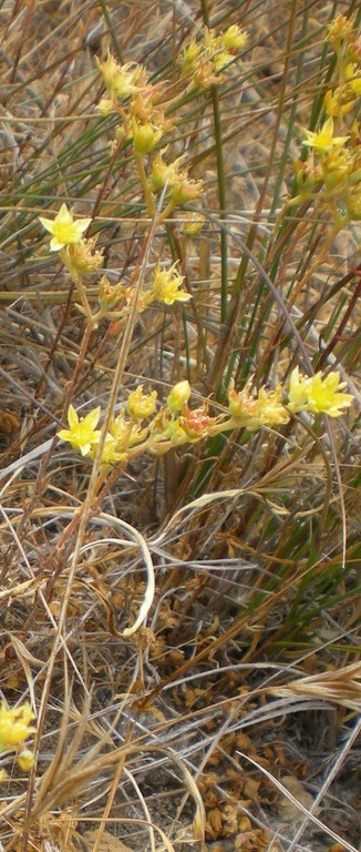
Photo Credit: Anna Bennett
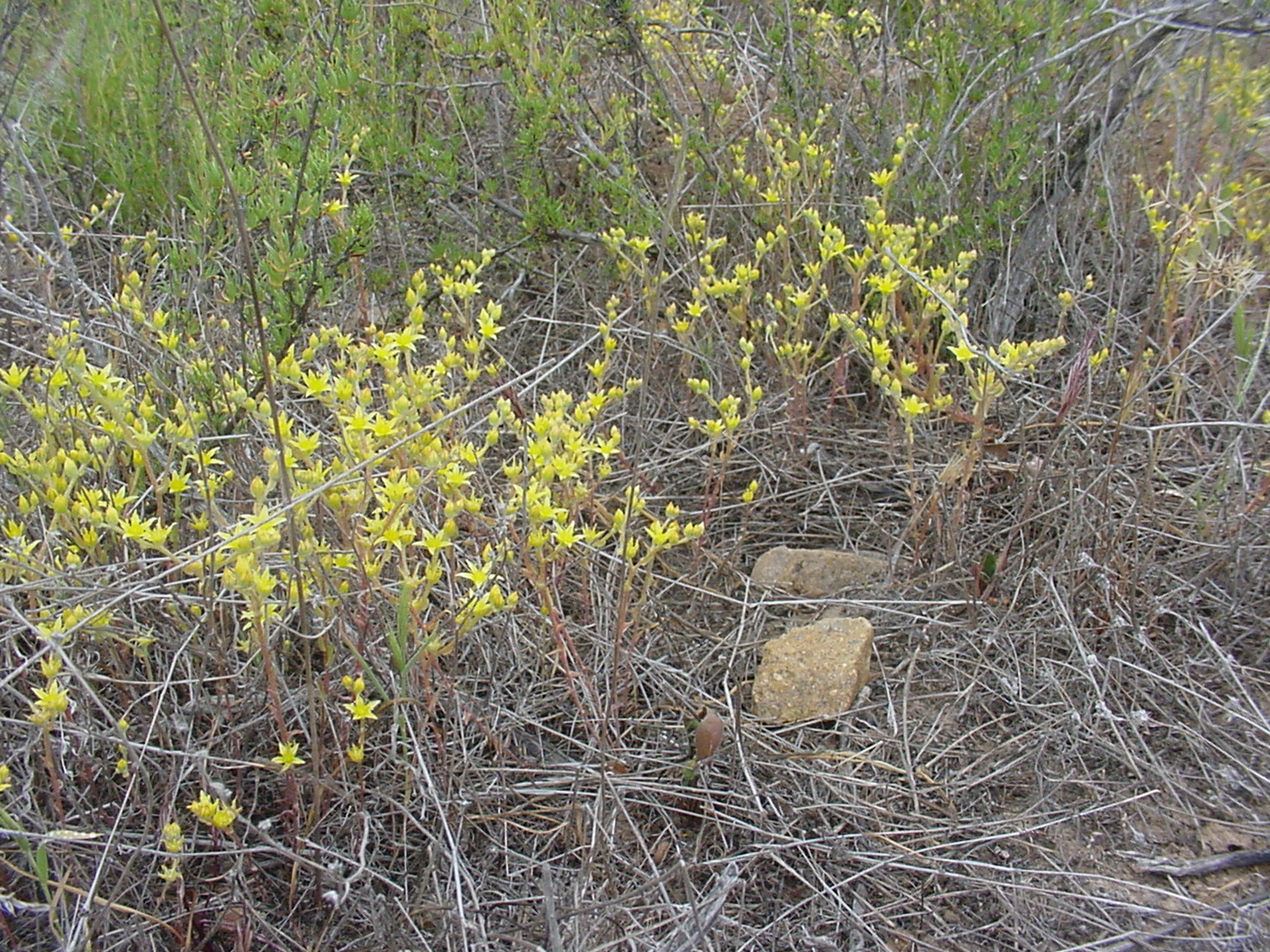
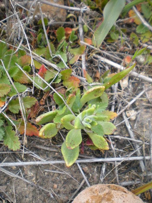
Photo Credit: USFWS: John Martin
Goal: Maintain or enhance variegated dudleya occurrences with self sustaining populations to increase resilience to environmental and demographic stochasticity, maintain genetic diversity, and improve chances of persistence over the long term (>100 years) in chaparral and coastal sage scrub vegetation communities.
Management units: 2, 3, 4, 6
In 2018 and 2020, inspect variegated dudleya occurrences on Conserved Lands (see occurrence table) using the regional rare plant IMG monitoring protocol to record abundance and collect habitat and threats covariate data to determine management needs.
| Action | Statement | Action status | Projects |
|---|---|---|---|
| IMP-1 | Based upon occurrence status and threats, determine management needs including whether routine management or more intensive management is warranted. | on hold | |
| IMP-2 | Submit project metadata, monitoring datasets and management recommendations to the MSP Web Portal. | on hold |
| Criteria | Deadline year |
|---|---|
| Surveys Completed in 2018 and 2020 with Management Recommendations | 2021 |
| Threat Name | Threat Code |
|---|---|
| Altered fire regime | ALTFIR |
| Human uses of the Preserves | HUMUSE |
| Invasive plants | INVPLA |
Management units: 2, 3, 4, 6
Beginning in 2017, conduct routine management actions as identified through the IMG monitoring in 2016, 2018 and 2020 at variegated dudleya on Conserved Lands (see occurrence table). Depending on the type and level of threat, management should be conducted as needed, not necessarily every year, and using BMPs with precautions to do no harm.
| Action | Statement | Action status | Projects |
|---|---|---|---|
| IMP-1 | Perform as needed routine management activities, such as protecting occurrences from disturbance through fencing and enforcement and controlling invasive non-native plant species =20% absolute cover. | available for implementation | |
| IMP-2 | Submit project metadata and management data to the MSP Web Portal. | available for implementation |
| Criteria | Deadline year |
|---|---|
| Routine Management Completed as Needed Based Upon Monitoring Recommendations | 2021 |
| Threat Name | Threat Code |
|---|---|
| Altered fire regime | ALTFIR |
| Human uses of the Preserves | HUMUSE |
| Invasive plants | INVPLA |
|
Brachypodium Control
This project used a science-based, experimental approach to develop treatment and restoration
strategies for the emerging invasive grass, Brachypodium distachyon (Brachypodium), on
conserved lands in southern San Diego County, CA. Phase I (2013-2015) included conceptual
models to inform experimentally-based treatment and restoration strategies; experimental
treatments (dethatching, herbicide, mechanical removal), monitoring, and seed collection,
bulking, and outplanting. Treatments continued in Phase II (2016-2017), using the most
effective management strategy (herbicide). See the Phase I and II reports for study results and
Best Management Practices (BMPs) for Brachypodium control. Herbicide is the most effective
treatment for controlling Brachypodium but timing of treatment is critical and multiple
treatments may be required in a single year, depending on rainfall and temperature. Herbicide
treatment of forbs becomes increasingly important as cover of Brachypodium and other
nonnative grasses decrease. Dethatching improves treatment effectiveness and stimulates the
soil seedbank (if present). The experimental design was coordinated with SDMMP and the City
of San Diego, and results may contribute to a regional analysis of Brachypodium control across
multiple sites, habitats, and microclimates.
|
|
Covered and Invasive Species Management: Crestridge Ecological Reserve and South Crest Properties
This was a two year, TransNet-funded study (#5001586) on Crestridge Ecological Reserve and South Crest properties. Both properties support MSCP covered species and sensitive habitats, and function as critical landscape linkages between the northern and southern MSCP. Surrounded by residential development and heavily impacted by the 2003 Cedar Fire, these properties are subject to ongoing invasive plant issues. Specific task actions included invasive plant and covered plant species mapping and risk assessment s, invasive plant control and experimental studies, and development of an early detection invasive control plan. This project was partially funded by SANDAG TransNet EMP Land Management Grant #5001586.
|
|
Dehesa Nolina Conservation and Management Strategy
The Conservation Biology Institute developed a science-based Conservation Vision and
Management Strategy for Dehesa nolina in San Diego County. The Conservation Vision
assessed the distribution, status, and threats of populations on conserved lands through data and
literature reviews, site visits, and interviews with land managers. Products included spatial data
layers, an updated matrix of threats and stressors, management recommendations, and prioritized
populations for management.
The Management Strategy focused on preserve-level management, using the existing Dehesa
nolina population on the South Crest Preserve to test/refine management techniques, including
species augmentation (seed collection, contract growing of plants, out-planting) and erosion
control. These actions also benefitted Dudleya variegata (variegated dudleya) and sensitive
native grassland habitat. These management actions complemented other Transnet-funded
management on South Crest; techniques refined in this project are applicable to other conserved
populations in the region. Project partially funded by SANDAG TransNet EMP Land Management Grant #5001763
|
|
Rare Plant Inspect and Manage Monitoring 2014-2026
From 2014-2026, a Management and Monitoring Strategic Plan (MSP Roadmap) monitoring objective for 30 rare plant species is to inspect occurrences to determine management needs. The inspect and manage (IMG) objective is implemented to document the status of rare plant occurrences and assess habitats and threats to develop specific management recommendations. IMG monitoring is implemented by a combination of land managers and contracted biologists in coordination with the SDMMP. Available rare plant data is posted below. New annual updates are typically posted in March. Based upon an evaluation of these data, a 2014-2026 monitoring schedule has been developed for the 30 rare plant species (attached below). Coordinating data collection across the region allows analyses of species and population trends over time and provides a better understanding of the association between habitat and threat covariates and population dynamics.
|
|
Spring Canyon/Goat Mesa Vernal Pool Restoration
The vernal pools at the Spring Canyon/Goat Mesa complex (J16-J18) and surrounding open space have suffered considerable off-road damage over the years. This damage has resulted in changes in hydrologic, flow patterns, and inundation characteristics. This vernal pools complex was identified by the adopted Recovery Plan for Vernal Pools of Southern California (USFWS 1998) as necessary to stabilize populations of the following endangered and threatened MSP species: E. aristulatum, P. nudiuscula, N. fossalis, O. californica, B. sandiegonensis, and S. wootoni. The Management Strategic Plan (MSP) for Conserved Lands in Western San Diego County (SDMMP) also lists other MSP species historically found onsite, including D. variegata, M. minimus, S. hammondii, and A cunicularia. Minimization of illegal off-road vehicle use is the primary goal. The main objective to reach the goal is to use to fence off as many of the key access points and areas of frequent off-road vehicle use throughout the City open space to protect the habitat for the endangered and threatened species that exist onsite. This will be done by hiring a fence contractor to provide all supplies and install the fence. This project was partially funded by SANDAG TransNet EMP Land Management Grant #5004945 .
|
|
Valley Fire Rare Plant Discovery Surveys
A project between the SDMMP and US Forest Service to establish and prioritize survey areas on Conserved Lands within the perimeter of the 2020 Valley Fire to document whether historic occurrences are extant and to discover new occurrences for 18 rare plant species. In 2022, AECOM and Conservation Biology Institute botanists surveyed areas for 18 target rare plant species and mapped the spatial extent of each new occurrence, counted or estimated the occurrence population size, and collected voucher specimens. They also photographed each new occurrence from a georeferenced location that captured a representative view of the occurrence. Botanists created a species list for the areas surveyed within the Valley Fire footprint. These areas included locations where rare plants were detected and mapped and negative data point areas where rare plants were not detected. In 2023, botanists shall again conduct surveys on suitable habitat on USFS lands burned in the 2020 Valley Fire. Results from these surveys should lead to a greater understanding of post-fire rare plant composition. In 2023, botanists may see species that did not emerge in the first year of surveys, and species found in the first year of surveys may have expanded their range. The 18 rare plant species included in the surveys are: San Diego thornmint (Acanthomintha ilicifolia), Marvin's allium (Allium marvinii), Western spleenwort (Asplenium vespertinum), Deane's milkvetch (Astragalus deanei), Encinitas baccharis (Baccharis vanessae), San Diego goldenstar (Bloomeria clevelandii), Orcutt's brodiaea (Brodiaea orcuttii), Lakeside ceanothus (Ceanothus cyaneus), San Miguel savory (Clinopodium chandleri), Variegated dudleya (Dudleya variegata), Mission Canyon bluecup (Githopsis diffusa filicaulis), Ramona horkelia (Horkelia truncata), Heart-leaved pitcher sage (Lepechinia cardiophylla), Felt-leaved pitcher sage (Monardella hypoleuca lanata), Chaparral nolina (Nolina cismontana), Gander's ragwort (Packera ganderi), Moreno currant (Ribes canthariforme), and Parry's tetracoccus (Tetracoccus dioicus).
|
Endemic to San Diego County and Baja California [1].
Thirty four known occurrences on Conserved Lands in MUs 2, 3, 4, and 6. Most occurrences are in MU 3, including Marron Valley, Otay Lakes, Otay Mountain, South Crest, Sweetwater Reservoir, Salt Creek, San Miguel Mountain, Proctor Valley, Rancho Jamul, and Goat Mesa. In MU4 occurs in and around Mission Trails Regional Park, Poway, and Sycamore Canyon and in MU6 is found at Black Mountain, Lusardi Creek, Santa Luz, and Santa Fe Valley.
None [2].
Associated with clay soils [2] supporting valley and foothill grasslands, open areas of chaparral, cismontane woodland, coastal scrub, and occasionally vernal pools. Habitats near the coast below 600 meters [3].
Crassulaceae family [2]. Identification should be regarded with some skepticism because this species is very closely related to, and often confused with, Dudleya multicaulis (many-stemmed dudleya) [3]. Without careful attention to correct taxonomic verification, the wrong taxon might be targeted at the site.
Small herbaceous perennial succulent [1].
Blooms April-June [2].
Threatened by development, grazing, and possibly nonnative plants [2]. Detrimental edge effects, including recreational activities [3].
Numbers tend to fluctuate with rainfall [4].
[1] Martin, J. 2005. “Variegated Dudleya ( Dudleya Variegata ) on San Diego National Wildlife Refuge.†San Diego, CA.
[2] CNPS, Rare Plant Program. 2016. Inventory of Rare and Endangered Plants (online edition, v8-02). California Native Plant Society, Sacramento, CA. Website http://www.rareplants.cnps.org [accessed 25 August 2016].
[3] McEachern, K., B. M. Pavlik, J. Rebman, and R. Sutter. 2007. “San Diego Multiple Species Conservation Program ( MSCP ) Rare Plant Monitoring Review and Revision.†San Diego, California. Beach Climate Data.†http://www.wrh.noaa.gov/sgx/climate/san-nrs.htm.
[4] Cheong, H., B. Miller, K. Martinez, P. Seiley, and M. Johnson. 2004. “City of San Diego Multiple Species Conservation Program.â€