Ecohydrology Research and Conservation Applications
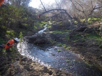
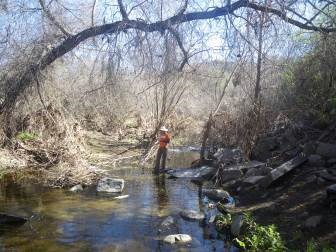
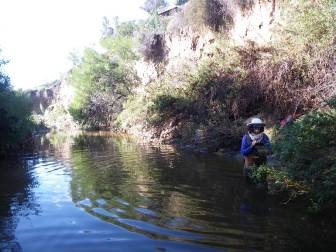
Non-native plants and animals with associated changes to ecological processes cause threats to native plants and animals. The San Diego Management and Monitoring Program's Management Strategic Plan (MSP) identifies these threats and stressors, and presents goals and objectives to monitoring their affects. The MSP has prioritized the study of the impacts of urban aseasonal flow on local and regional stream systems. The issue of seasonal wetlands in urbanizing landscapes has received varying amount of attention. The runoff can create a range of results from increased soil moisture levels, to geomorphic changes in creeks and perennial flows in xeric landscapes. USGS is working with SDMMP and their partners in the Management Strategic Plan Area (MSPA) to determine what GIS covariates of land cover/land use might correlate with field measurements of the phenology of water presence in small watersheds. This will help to identify where urban runoff is providing habitat for aquatic nonnative problem species in areas inhabited by arroyo toads, western pond turtles and vernal pool areas. Study sites were selected using a spatial model including layers for watershed size, land use, and conserved lands. Site selection also considered surface water monitoring sites for arroyo toad monitoring (Brown et al. 2016) and surface flow monitoring stations used by the California Water Quality Control Board, San Diego Region (SDRWQCB unpub. data). The combination of the three studies provide a network of surface water availability and temperature data from coastal San Diego to the foothills of the Cuyamaca, Laguna, Palomar, and Santa Margarita mountain ranges. A total of 56 sites were selected, assessed, and Stream Temperature, Indeterminacy, and Conductivity (STIC) loggers were deployed. This adds to the existing 64 loggers that were deployed to measure Arroyo toad habitat. For 120 loggers, the following steps took place. 1. The logger was placed in the field and the location was recorded with a high resolution GPS. 2. Photographs were taken of each logger location 3. Each site was revisited several times through 2015-2017 and native and non-native aquatic species were recorded. 4. The drainage area (or watershed size) for each logger was calculated in ArcGIS. 5. The land use upstream from the logger was assessed by calculating the percent urban, percent agriculture, percent open space, percent residential, and percent commercial/industrial. 6. Temperature and Conductivity were collected from loggers and graphed. Future work will include continued logging and graphing of temperature and conductivity, continued survey of the sites for native and non-native aquatic species, and statistical analysis
Project Groups
-
SDMMP_2018_9990324 Urban Runoff Studies
Project Focus
California Treefrog, goldfish, largemouth bass, Pacific Chorus Frog--TREEFROG
Robert N. Fisher
U.S. Geological Survey
San Diego Management and Monitoring Program
Emily Perkins
Chris Brown
Project Protocol
Water temperature and streamflow intermittency are critical parameters influencing aquatic ecosystem health. Low-cost temperature loggers have made continuous water temperature monitoring relatively simple, but determining streamflow timing and intermittency using temperature data alone requires significant and subjective data interpretation. Electrical resistance (ER) sensors have recently been developed to overcome the major limitations of temperature-based methods for the assessment of streamflow intermittency. This technical note introduces the STIC (Stream Temperature, Intermittency, and Conductivity logger); a robust, low-cost, simple to build instrument that provides long-duration, high-resolution monitoring of both relative conductivity (RC) and temperature. Simultaneously collected temperature and RC data provide unambiguous water temperature and streamflow intermittency information that is crucial for monitoring aquatic ecosystem health and assessing regulatory compliance. Wi
Strategic Elements
- FY15-16 - 2.1
Altered hydrology
Goal: Reduce the impact of urban runoff and aseasonal flow on the highest priority MSP species and riparian habitat so that species can presist over the long term (>100 years) in areas upstream and downstream of urban land uses.
MON-RES-STIC ALTHYD-1
Management units: 1, 2, 3, 4, 5, 6, 7, 8, 9, 10, 11
Continue USGS research study using STIC sensors to measure water temperature and presence in chosen stream channels. The final report should include an analysis investigating the relationship between upstream urban land uses and the number of days with water present. The data should be available in a format that will aid the creation of a hydrologic management plan.
| Action | Statement | Action status | Projects |
|---|---|---|---|
| RES-1 | Monitor STIC sites on a regular basis to capture stream data and necessary covariate data. | In progress | Ecohydrology Research and Conservation Applications |
| RES-2 | Analyze data and covariates to invesigate the relationship between stream conditions and watershed land use. | In progress | Ecohydrology Research and Conservation Applications |
| RES-3 | Submit project metadata and report to the MSP Web Portal. | waiting for precedent action | Ecohydrology Research and Conservation Applications |
| Criteria | Deadline year |
|---|---|
| Final report of STIC data and analysis | 2021 |
| Threat Name | Threat Code |
|---|---|
| Altered hydrology | ALTHYD |
| File name | Lead Author | Year | Type |
|---|---|---|---|
| Amphibian IBI and Hydrological Impact Score | Fisher, Robert N. | 2019 | powerpoint presentation |
| Effects of drought on aquatic biodiversity and the effect of landscape-scale urbanization on aseasonal flow | San Diego Management and Monitoring Program; U.S. Geological Survey, Western Ecological Research Center | 2019 | powerpoint presentation |
| Longevity and population age structure of the arroyo southwestern toad (Anaxyrus californicus) with drought implications | Fisher, Robert N.; Brehme, Cheryl; Hathaway, Stacie; Hovey, Tim; Warburton, Manna; Stokes, Drew | 2018 | journal article |